The importance of Distance and Measurement in the history of Civilization

The Importance of Distance and Measurement in the History of Civilization

Distance is one of the most important ideas in the history of human progress. Before mankind could build cities, cross oceans, defend territory, mine the earth, or reach space, people first had to understand how far one point was from another. Measurement turned imagination into construction, giving builders, engineers, sailors, miners, soldiers, and scientists the ability to plan with accuracy instead of guesswork. Every great project in civilization depends on knowing length, height, width, depth, angle, span, radius, elevation, and scale. Without distance and measurement, the greatest achievements of mankind would have remained ideas instead of becoming buildings, pyramids, dams, forts, vessels, roads, mines, bridges, and spaceships.

Buildings depend on accurate distance measurement from the first foundation stake to the final roofline. Builders must know the exact distance between walls, columns, floors, beams, plumbing lines, electrical runs, stairways, windows, and doors for a structure to stand safely and function properly. Even a small error in measurement can cause uneven floors, weak load-bearing points, poor drainage, or walls that fail to align. Throughout history, the ability to measure height, width, depth, and spacing allowed people to move from simple shelters to homes, temples, towers, factories, and skyscrapers. The history of architecture is really a history of learning how to control distance with greater precision.

Pyramids are among the clearest examples of how measurement shaped ancient civilization. The massive pyramids of Egypt required careful calculation of base length, slope angle, stone size, chamber placement, passageway distance, and alignment with the surrounding landscape. Ancient builders had to move enormous stones across long distances and place them with such accuracy that the structure could rise evenly for hundreds of feet. The success of a pyramid depended not only on labor, but on the ability to measure distance horizontally, vertically, and diagonally with remarkable consistency. Without reliable measurement, pyramids would have become unstable piles of stone instead of enduring monuments to engineering discipline.

Dams require an exact understanding of distance because they must hold back one of nature’s most powerful forces: water. Engineers must measure the width of a river valley, the depth of the water, the height of the dam wall, the distance to nearby communities, and the pressure created by the reservoir behind it. A dam that is too low, too narrow, too thin, or poorly placed can fail with catastrophic consequences. From ancient irrigation dams to modern hydroelectric projects, successful dam construction depends on surveying, elevation measurement, flow calculations, and precise placement of materials. Distance measurement allows mankind to transform water from a threat into a source of power, farming, transportation, and survival.

Forts were built around the strategic importance of distance. Military planners had to measure how far an enemy could march, how far arrows or cannonballs could travel, how thick walls needed to be, and how much space was required between towers, gates, barracks, and defensive positions. The distance between a fort and rivers, roads, harbors, hills, and borders often determined whether it could protect a city or control a region. A successful fort was not just a strong building, but a carefully measured defensive system. Throughout history, the ability to measure distance helped determine who could defend land, control trade routes, and survive attack.

Vessels depend on measurement because every ship, boat, and seagoing craft must balance distance, weight, proportion, and navigation. Shipbuilders must measure hull length, beam width, mast height, cargo space, draft depth, sail area, and the distance between structural ribs to create a vessel that can float, steer, and survive rough water. Sailors also depend on measuring distance across oceans, using tools and methods to determine speed, direction, latitude, longitude, and distance from shore. The success of trade, exploration, fishing, warfare, and migration depended on knowing both the dimensions of the vessel and the distances it could travel. Civilization expanded across seas because people learned how to measure the world beyond the coastline.

Roads are built on the practical measurement of distance between places. Ancient road builders had to measure routes through forests, mountains, deserts, valleys, towns, and rivers to create paths that were direct, durable, and usable. The distance between settlements determined trade, military movement, communication speed, and the growth of empires. Road construction requires measuring grade, width, drainage, curve radius, bridge crossings, and the amount of material needed for each mile. Roads turned geography into opportunity because measurement made it possible to connect people, markets, armies, and ideas across long distances.

Mines rely on distance measurement because miners work in hidden spaces where mistakes can be deadly. Before digging, surveyors must measure the distance to mineral deposits, the depth below the surface, the angle of tunnels, the thickness of rock layers, and the location of water, gas, and unstable ground. Inside a mine, accurate measurement helps prevent tunnel collapse, flooding, poor ventilation, and workers becoming lost underground. Mining also requires calculating the distance needed to move ore, support shafts, install tracks, pump water, and bring materials safely to the surface. The history of mining is a history of measuring depth, direction, and danger beneath the earth.

Bridges are among the greatest demonstrations of mankind’s ability to measure distance and overcome it. A bridge exists because a gap must be crossed, whether that gap is a river, canyon, valley, roadway, or harbor. Engineers must measure the span between supports, the height above water or ground, the load the bridge must carry, the movement caused by wind, and the expansion created by heat and cold. If those distances are miscalculated, the bridge can sag, crack, twist, or collapse. Successful bridges prove that when humans can measure distance accurately, they can turn separation into connection.

Spaceships represent the most advanced use of distance measurement in human history. To build and launch a spacecraft, engineers must measure tiny distances inside engines and electronics as well as enormous distances between Earth, the Moon, planets, satellites, and orbital paths. Space travel depends on exact calculations of speed, fuel, angle, gravity, altitude, trajectory, timing, and distance traveled. A small measurement error at launch can become a massive navigational failure thousands or millions of miles away. Spaceships show that mankind’s future depends on the same principle that shaped its past: the ability to measure distance with precision and turn that knowledge into achievement.

From the earliest stone structures to rockets leaving Earth’s atmosphere, distance has always been one of civilization’s master problems. Measurement gave human beings the power to plan, compare, build, travel, defend, explore, and improve. It allowed people to move beyond instinct and create repeatable systems of construction, engineering, navigation, and science. Every successful project in history began with someone asking how far, how high, how deep, how wide, or how long. The more accurately mankind learned to measure distance, the farther civilization was able to go.
How it works.

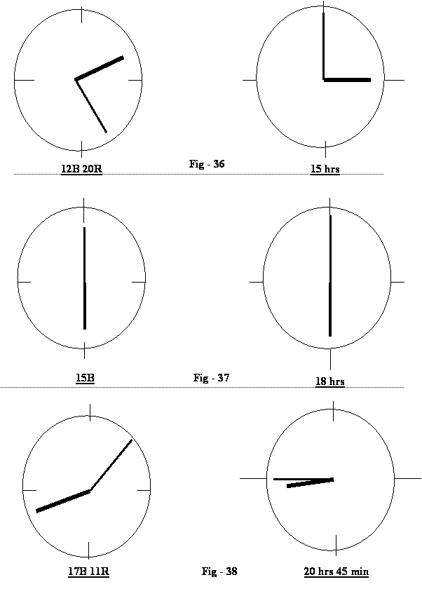
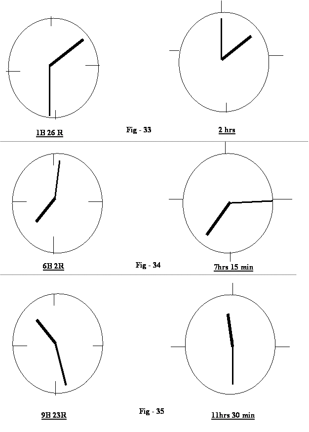
From the above figures, one can see the transition from the make belief time shown in the dial column on the right. The reality of the earth’s equatorial movement shown in the column to the left would be very easy to achieve.  One would however have to get used to the idea of distances being traveled with respect to the sun and discard the make belief notion of time.

Examples from the Table of Dial Fig-32:

  1. John would ask Peter what is the distance now?  Peter looking at his distance piece would reply, it is 6 Basics and 2 Ranges instead of the imaginary 7 hrs and 15 minutes(See Fig-34).
  1. Akshay Kumar  inviting Dina Chandran  to an evening out and telling her to be ready  for him to pick her  up at 17 Basics and 11 ranges instead of the imaginary 20 hrs and 45 minutes .(See Fig-38)

How it would be made to work.

The authors, being a professional engineer, is having the distance piece patented and would then invite Watch manufacturing companies to lend their support to manufacture these Distance Pieces in place of the Time Pieces. They are now manufacturing in order to make the distance pieces a reality, (which in fact are already a reality) but have not been conceived and built so far.  WISHING ALL READERS HAPPY DISTANCES. This is only the beginning of endless Distances.

From Page 41

Provided there is such a thing a Time, however, in reality Time is only a figment of human imagination. As such, Time cannot be a function of Distance.

Six Comparisons of Distance Pieces/Time Pieces

Six Comparisons of Distance Pieces/Time Pieces

Table for comparing 20 Atichinna Kms Dial with 12 Hours Dial :

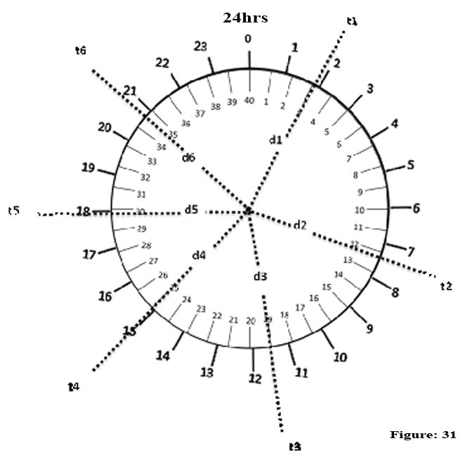
Six distances that the earth’s equator rotates in front of the Sun starting at 0 from a new length has been shown in the above dial Fig-31. These have also been shown in the table below showing the so called time comparison to the distance moved. [These distances moved give us (see also page 39) different temperatures & light and dark effects which have led us to the false belief in time.

Atichinna Scale/12 Hours Dial

1                                                        

d1– t1

1 hrs

1 ÷ 12 x 20  = 1.6

1.6 – 1 = 0.1 and 1B

0.6 x 100 = 66 R

As such 1 B , 66 R  = 1 hrs

4

d4 – t4

7 hrs, 30 mins

7.5 ÷ 12 x 20 = 12.5

12.5 – 12 = 0.5 and 12B

0.5 x 100 = 50R

As such 12 B and 50 hrs = 7 hrs and 30 mins 

2

d2  –  t2

 3 hrs , 40 min.

3.66 ÷ 12.5 x 20 = 6.1

6.1 – 6 = 0.1 and 6B

0.1 x 100 = 10 R

As such 6 B and 10 R=3 hrs and 40 min.

5

d5   t5

9 hrs

9 ÷ 12.5 x 20 = 12.5

As such 15 B = 9 hrs


3

d  – t3

5 hrs,  45 min.

5.75 ÷ 12 x 20  = 9.58

9.58 – 9 = 0.58 and 9B

0.58 x 100 = 58 R

As such 9 B and 58 R = 5 hrs and 45 mins

6

d6   – t6

10 hrs, 20 mins

10.33 ÷ 12 x 20 = 17.2

17.2 – 17 = 0.2 and 17B

.2 x 100 = 29R

As such 17 B and 20 R=10 hrs and 20 min


Sl No


Fig  -31


B       R     P

Hrs.  Min.  Sec.


Lambu Kilometer


Normal Kilometer/sec

1 1

1

1B  66 R

1 hrs

3345.84


3339.58

5400 sec

2 2

2

6 B  10 R

3 hrs      40 min

12245.7


12222.8

12600 sec

3 d3

3

9 B   58 R

5 hrs    45 min

19238.5


19202.5

19800 sec

4 d4

4

12B   50R

7 hrs   30 min

25093.8


25046.8

27000 sec

5 5

5

15B

9 hrs

30112.5


30056

34200 sec

6 d 6

6

17B  20 R

10 hrs    20 min

34562.5


34997.8

37800 sec

Table for comparing 40 Atichinna Km Dial with 24 Hours Dial :

Six distances that the earth’s equator rotates in front of the Sun starting at 0 from a new length has been shown in the above dial Fig-31. These have also been shown in the table below showing the so called time comparison to the distance moved. [These distances moved give us (see also page 39) different temperatures & light and dark effects which have led us to the false belief in time.]

Atichinna Scale/24 Hours Dial 

1                                                                                                                   

d1– t1

2 hrs

2 ÷ 24 x 40  = 3.3

3.3 – 3 = 0.3 and 3B = 1B

0.3 x 100 = 33.3R R

As such 3 B , 33.3 R  = 2 hrs

4

d4 – t4

15 hrs

15 ÷ 24 x 40 = 25

25B

As such 25 B = 15 hrs 

2

d2  –  t2

 7 hrs , 15 min.

7.25 ÷ 24 x 40 = 12.08

12.08 – 12 = 0.08 and 12B

0.08 x 100 = 8 R

As such 12 B and 8 R=7 hrs and 15 min.

5

d5   t5

18 hrs

18 ÷ 24 x 40 = 30

As such 30 B = 18 hrs


3

d  – t3

11 hrs,  30 min.

11.5 ÷ 24 x 40  = 19.1

19.1 – 9 = 0.166 and 19B

0.166 x 100 = 16.6 R

As such 19 B and 16.6 R = 11 hrs and 30 mins

6

d6   – t6

20 hrs, 45 min

20.75 ÷ 24 x 40 = 43.58

34.58 – 34 = 0.58 and 34B

.58 x 100 = 58R

As such 34 B and 58 R=20 hrs and 45 min


Sl No


Fig  -31


B       R     P

Hrs.  Min.  Sec.


Lambu Kilometer


Normal Kilometer/sec

1 1

1

3B  33.3 R

2 hrs

3345.8


3339.5

7200 sec

2 2

2

12 B  8 R

7 hrs      15 min

12128.6


12105.9

26100 sec

3 d3

3

19 B   16.6 R

11 hrs    30 min

19238.5


19202.6

41400 sec

4 d4

4

25B

15 hrs

25093.8


25047

54000 sec

5 5

5

30B

18 hrs

30112.5


30056

64800 sec

6 d 6

6

34B  58 R

20 hrs    45 min

34713.1


34648

74700 sec

Dial for comparison  of 40 Atichinna Kilometer Dial with 24 hrs Dial                                                       

Given below is an illustration of how much distance the earth’s equator travels with respect to the sun i.e starting at a new length in comparison to the nonexistent & fictitious myth called time. Looking at Figure-31, we have a circle on a dial with 24 equispace divisions on its outside. These 24 divisions depict the so called 24 hours. i.e a day & night. On the inside of the same circle of the dial we have 40 equispaced divisions each division is 1000 Atichina kilometers totaling to 40000 Atichina kilometers represents the the earth’s which is the abbreviated and modified circumferential distance from 40075 kilometer to 40000 kilometer of the earth’s equatorial length. Six examples have been shown in dotted lines on the dial in Fig-31 of how much the earth rotates in Atichina Kilometers in front of the Sun using the Atichinna scale, d1—d6 shows the distances travelled by the earth in Akms in front of the sun starting from the zero position. Also t —- tshows the time comparison.

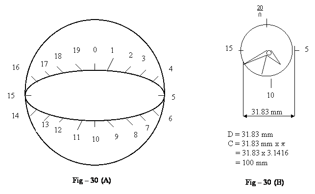
In the  Fig-30(A) & Fig-30(B) shown below, the earth’s equator is  divided  into  20 divisions after  having  converted  normal  kilometers  to Lambu  kilometers. As such, the length of the complete equatorial circumference is 40,000 LAkms and each of the 20 divisions is 2000 Lambu kilometers. Also we see in Fig-30(B) the distance piece of a wrist watch size having a circumference of 100 mm is also divided into 20 parts and further into 5 divisions. i.e (20×5 mm= 100 mm) (Divisions not shown here).                                                                  

Constructing a distance piece according to the Lambu Kilometer and the Atichinna  Kilometer Scale.

The difference in length between 1 Lambu mm and 1mm is as shown above, only about a maximum of 0.2 %, so while constructing a distance piece we can ignore 0.2 % (i.e. 0.002 mm) of a mm. We therefore take a circumference of the dial as 100 mm ¸ p = 31.83 mm  diameter (see fig-30 (B)).  We first divide the 100-mm circumference into 20 Basics such that each part equals 5 mm., so that we have 20 Basics x 5 mm = 100 mm.

EQUATOR MOVEMENT               NEEDLE  MOVEMENT

       Eq                                                B

40,000 L km                                        100 mm

*  2,000 L km                                      5 mm    (40,000 ¸20 = 2000 &100 ¸ 20 = 5)

     400 L km                                        1 mm    (2000 ¸ 5 = 400 & 5 ¸ 5 =1)

EQUATOR MOVEMENT               NEEDLE MOVEMENT

     Eq                                                   R                    

  2,000 L km                                        100 mm

   100 L km                                          5 mm     (2,000 ¸ 20 = 100 & 100 ¸ 20 = 5)

     20 L km                                          1 mm     (100 ¸ 5 = 20 & 5 ¸ 5 = 1)

EQUATOR MOVEMENT               NEEDLE  MOVEMENT

        Eq                                                P

  20 L km                                             100 mm

  1 L km                                               5 mm      (20 ¸ 20 = 1 & 100 ¸ 20 = 5)

  0.2 L km  (200 meters)                       1  mm      (1 ¸ 5 = 0.2 & 5 ¸ 5 = 1)

*1 Basic = 2,000 Lambu Kilometer.    


Reasons for choosing Atichinna kilometers :

20 Basics of the Atichinna kilometers are closer to the 24 divisions of the Chotu kilometers. Further, the 100 Ranges and 100 portions of the Atichinna Kilometer are metric.This makes calculations with the Atichinna Kilometer easier. Also although Chinna Kilometers have a scale of   10 x 100 x 100, which is purely metric as the big Basic divisions are 10.  The Atichinna has the advantage of having a scale for the Basic as being 2 x 10.  There is no such thing as “time”: – however, two parts of the revolution of the Earth’s Equator are the bright part and the dark part, as the Earth transits in front and away from the sun. As such, the 2 parts of the Atichinna kilometers indicate both the bright and the dark parts of the Earth’s Equator as it revolves in front of the Sun.

The Best Construction for the Distance Piece

The standard kilometer divides itself 40075 times into the Equator.  This number 75 is not convenient for the calculations as we get decimal points.  If we were to take the Lambu Kilometer i.e. equal to 1.001875 kilometers and divide this into the length of the Equator, we get exactly 40000 Divisions.  We also notice that the difference between 1 Lambu Kilometer and the standard kilometer is (1.001875 – 1) = 0.001875 or in other words, on a 1000 meters, only about 1.9 meters. Say a maximum of 2 meters or 2/1000 =  0.002.  It would be much more convenient to standardize the kilometer as one forty thousandth of the length of the equator rather than the meter as being one tenth millionth of the distance from the equator to the North Pole. In any case distance from the North Pole to the Equator is not very logical as the earth does not rotate from the north pole to the Equator but the Earth’s Equator rotates around its North Pole, South Pole Axis. As such, it is more logical to standardize the kilometer as 1/40,000th  part of the Equator. So, having standardized on the Lambu Kilometers as being 1/40,000th  of the length of the Equator, the best scale to be adopted would be the Atichinna kilometer, the scale of which is repeated here once again i.e. 20 Basics, 100 Ranges and 100 Portions which is  20 x 100 x 100 = 200,000.

Also The Earth’s equatorial circumferential distance is…….. L=40,075 kms. If 40,075kms is divided by 2 we get 20037.5kms. this number is not a complete number but is with a decimal point. If we subtract a very small amount which is 75 kms only 1/ 534th of the complete equatorial distance. We are left with the equatorial length of 40000 kms which can be divided by 2 giving us to equal and decimal free numbers each being 20000 kms which is much easier to calculate with.

In case we don’t want to reduce the equatorial distance then we can add 5 kms to 40,075 kms making it 40,080 kms. Which can be divided into 2 exactly equal parts of 20,040 kms each or into 24 parts each being 1670 kms. Now looking at page 9. For suitable divisions of the equatorial length. We observe in all the four cases below the earth’s equatorial length of 40,075 kms has been reduced to 40,000 kms . so that it’s a decimal free divisible number. Whereas, on the other hand this equatorial distance has been increased to 40,080 kms in order that it may get properly divided by 24hrs so that distance of each hour travel by the equator would be 1670 kms a decimal free number. As when 40,080 kms is divided by 24 we get 1670 kms which is a decimal free whole number.


Lambu kms       25x40x40 = 40,000 x 1 = 40,000kms
Chotu kms        24x60x60 = 86400 ¸2.16 = 40,000kms
Nicku kms        28x70x70 = 137200 ¸3.43 = 40,000kms
Atichinna kms    20x100x100 =200000 x0.2 = 40,000kms.